Prime Minister Lee Hsien Loong, planted a tree on 9th July 2016, at Sengkang Riverside Park, to launch the first 63km of the Round Island Route project, which will tender for Construction shortly.
The Round Island Route (RIR) is a proposed 150km long recreational walking and cycling route that circumnavigates Singapore.
Sengkang Riverside Park was selected for the ceremony since it is the site of a major new bridge that will directly link both sides of the park for cyclists and pedestrians using the RIR.
RIR Node at Rowers Bay - Aerial view by Stephen Caffyn Landscape Design
As well as being busy working recently working on the Construction Details and Documentation for the Tender of Phase 1 of the Coastal Adventure corridor, SCLD also produced most of the 3d models, graphics, and visualizations of the Round Island Route proposals used in the promotional video of the project and press releases.

Round Island Route visualization of Changi Bay by Stephen Caffyn Landscape Design
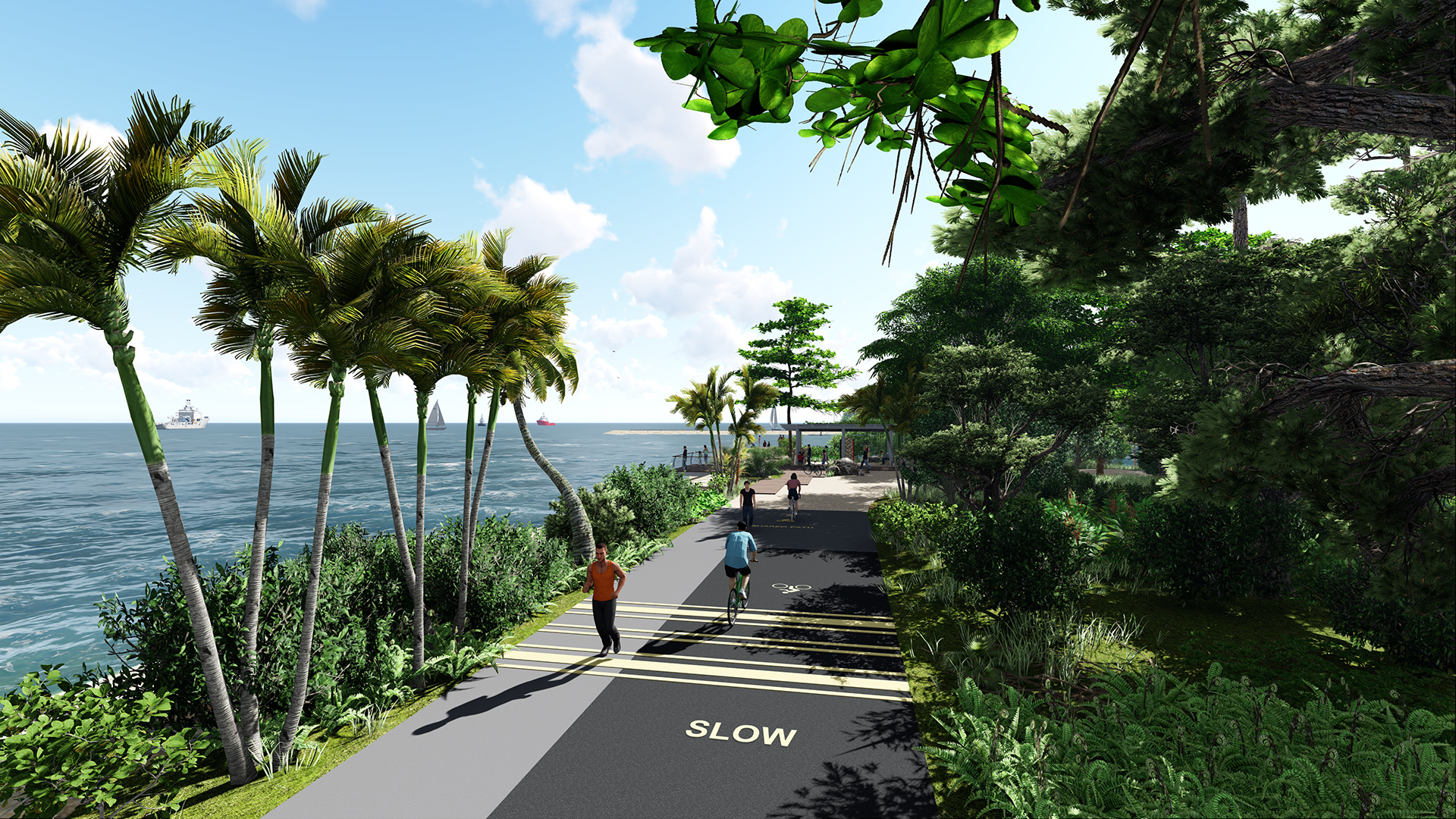
View of track near Changi Bay shelter on the Round Island Route Coastal Adventure by Stephen Caffyn Landscape Design
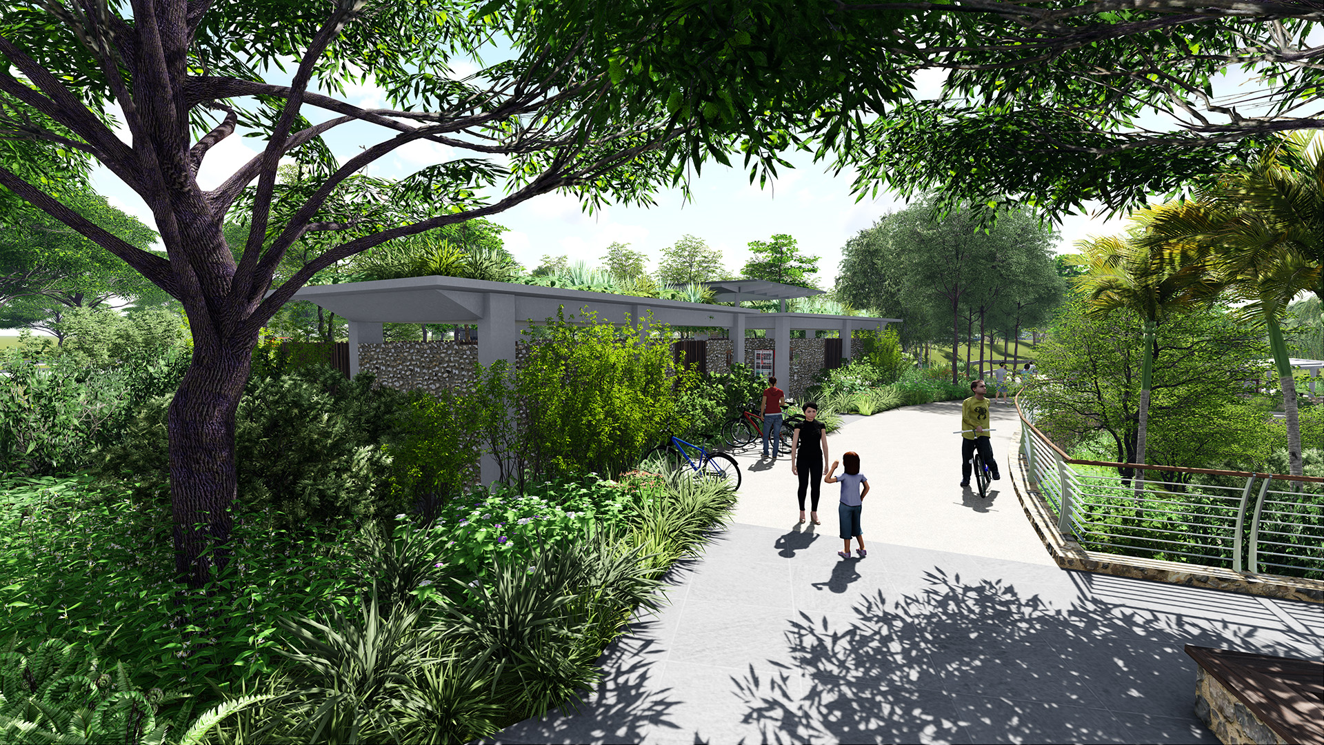
Lookout area and restrooms at Rower's Bay on the Round Island Route by Stephen Caffyn Landscape Design

Visualization of Rower's Bay wetland area and boardwalk from Lower Seletar Reservoir

View of Round Island Route shelter at Changi Bay area by Stephen Caffyn Landscape Design
The Round Island Route (RIR) – Changi Bay Area, Singapore.
Visualization Clips:
These clips show the cycle and footpath at Changi Bay, near Changi Exhibition Centre. Clips include the Beach area with toilets facilities, the landscape bridge treatment across a canal, and lookout point with shelter near mangroves.
Aerial view of RIR Shelter at Changi Bay by SCLD
All our original uncut (and at normal speed) video clips can be seen on Stephen Caffyn Landscape Designs YouTube Channel
RIR Shelter and Seawall at Changi Bay by Stephen Caffyn Landscape Design
Overview of Changi Bay area vegetated bridge over Canal by Stephen Caffyn Landscape Design
RIR Shelter at Changi Bay by Stephen Caffyn Landscape Design
Bridge over canal at Changi Bay by Stephen Caffyn Landscape Design
RIR Restrooms on the Beach at Changi Bay by Stephen Caffyn Landscape Design
Round Island Route (RIR) - Node at Rower’s Bay, Singapore.
Visualization Clips:
These clips show Rower’s Bay at Lower Seletar Reservoir, next to the dam, where we bring visitors next to the water and provide facilities such as shelters, toilets, lookout points, and a boardwalk next to a new wetland area.
RIR Node at Rowers Bay - Boardwalk View by Stephen Caffyn Landscape Design
RIR Node at Rowers Bay - View at Restrooms and entrance area by Stephen Caffyn Landscape Design (SCLD)
Visualization view from the Reservoir towards the RIR Node at Rowers Bay, Seletar by Stephen Caffyn Landscape Design
Watch the press and Stephen Caffyn Landscape Design's website for more updates and information on the Round Island Route project in the near future.